A map of Wollaston in the 1830s
1830s
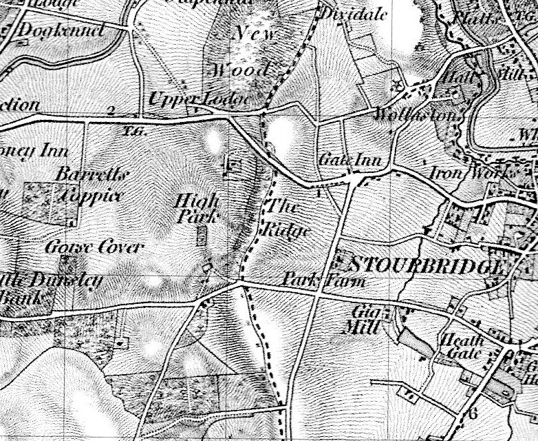
This map, dating from the 1830s, shows the main roads including the turnpike road from Stourbridge to Bridgnorth. The Act which was for the making and maintaining the road was given Royal Assent on 11th April 1816. The main road through the village still follows the same route and the Gate Inn at the junction of what is now High Park Avenue was where payment would have been made to use the road. The public house at the junction is still called The Gate Hangs Well. What is now called Vicarage Road, renamed in the 1860s, has the symbol denoting the windmill where the Vicarage now stands. Wollaston Hall is also clearly marked as is the iron works which provided so much employment in Wollaston.
Previous: High Park School Mini bus
Comments
Aw, this was a very nice post. In thought I want to put in writing like this moreover taking time and actual effort to make an excellent article but what can I say I procrastinate alot and not at all seem to get something done.
James -
iniki
vapormax
prada sunglasses
yeezy 700
yeezy boost 350 v2
kyrie shoes
yeezy boost 350
asics kayno
tory burch shoes
james harden shoes
yeezy shoes
michael kors outlet
jordan shoes
cat boots
cartier bracelet
adidas yeezy
yeezy shoes
air presto
yeezy boost 350
air yeezy
links of london
GRGRGE
ccc -
clb0319
ugg boots
supreme clothing
michael kors
replica watches
nike shoes
longchamp handbags
canada goose
canada goose
kate spade
philipp plein outlet
longchamp outlet
moncler jackets
cheap mlb jerseys
moncler jackets outlet
nmd shoes
coach outlet
nike air max outlet
adidas yeezy
pandora store
pandora jewelry
salvatore ferragamo
oakley sunglasses
nba jerseys
cheap nike air max
coach outlet
yeezy boost
mulberry bags
adidas superstar
ferragamo shoes
pandora charms uk
canada goose outlet
adidas yeezy
yeezy boost
louis vuitton outlet
cheap jordans
pandora jewelry
tory burch outlet
nmd adidas
harden vol 1
jordans
canada goose sale
prada outlet
coach outlet online
cheap nfl jerseys
cheap jordans
timberland outlet
pandora jewelry official site
ralph lauren
jordan shoes
louis vuitton outlet online
clb0319
clibin clibin -
20180407 xiaoou
burberry outlet store
nfl jerseys
canada goose
cheap jordan shoes
coach outlet online
oakley sunglasses
canada goose outlet store
rolex watches for sale
kate spade outlet
hermes outlet
michael kors outlet online
longchamp outlet
birkenstock shoes
lacoste soldes
new balance shoes
cheap ray ban sunglasses
oakley sunglasses wholesale
cheap oakley sunglasses
true religion outlet uk
air max shoes
michael kors outlet
oakley sunglasses
jordan shoes
michael kors outlet online
pacers jerseys
oakley sunglasses wholesale
coach factory outlet
christian louboutin sale
cavaliers jerseys
mbt shoes outlet
2018 world cup jerseys
san antonio spurs
pandora charms
cheap snapbacks
gucci outlet store
cheap oakley sunglasses
los angeles lakers jerseys
gucci outlet online
ferragamo shoes
coach outlet
louis vuitton outlet stores
michael kors outlet clearance
christian louboutin shoes
cheap nhl jerseys
oakley sunglasses wholesale
coach factory outlet
camisetas futbol baratas
ralph lauren uk
swarovski outlet store
cheap nhl jerseys
ralph lauren outlet
uggs outlet
coach outlet store online clearances
canada goose outlet
michael kors outlet
jordan shoes
ugg boots
ralph lauren polo
coach outlet online
prada handbags
supra shoes sale
canada goose outlet
xiaoou -
ray ban sunglasses
fitflops
ralph lauren
adidas yeezy boost
longchamp handbags
michael kors outlet
coach outlet
coach outlet
supreme new york
adidas yeezy
adidas yeezy
ralph lauren
yeezy boost
ray ban sunglasses
tods outlet
kate spade handbags
ecco shoes
rolex watches
coach outlet online
polo ralph lauren
michael kors outlet
air jordans
coach outlet
louis vuitton handbags
adidas campus
pandora jewelry
jordan shoes
canada goose jackets
michael kors outlet
canada goose sale
180411yueqinccc
kakakaoo -
adidas outlet
cheap mlb jerseys china
tory burch outlet online
canada goose outlet
kate spade outlet
cheap nike air max
cheap uggs
coach outlet
nike air max
timberland boots
kate spade outlet
michael kors outlet clearance
nike outlet
nike outlet
tory burch outlet
pandora charms
polo outlet
coach outlet
coach outlet
michael kors outlet
ugg outlet
nike shoes
ugg boots on sale
nike outlet online
converse outlet store
cheap mlb jerseys
uggs outlet
birkenstock sandals
timberland boots
ugg boots on sale
180411yueqin
kakakaoo -
2018.4.18chenlixiangtods shoes
mulberry handbags
bottega veneta
swarovski gioielli
clarks shoes
adidas shoes
adidas outlet store
orologi rolex
burberry sale
longchamp
michael kors
hogan shoes
beats by dre
new balance
hogan
softball bats
germany world cup jersey
prada outlet
christian louboutin
converse shoes
timberland pas cher
christian louboutin
montre pas cher
dansko shoes
mont blanc pens
michael kors uk
replica watches
chrome hearts jewelry
kevin durant shoes
nike air max 97
michael kors outlet
bottega
sac michael kors
roshe run
cartier bracelet
christian louboutin
adidas outlet store
reebok shoes
montre homme
timberland boots
jordan 3
argentina world cup jersey
hermes
adidas slides
longchamp handbags
beats headphones
jordan 12
jordans
roty burch outlet
nike free
2018.4.18chenlixiang66556656566656
chenlixiang -
2018.7.10chenlixiangpandora charms
balenciaga shoes
celine
roty burch outlet
michael kors outlet online
nike air max 95
flip flops
miu miu shoes
air max
oakley sunglasses
bottega veneta
sac longchamp
versace handbags
tiffany co
jordan 5s
lebron 11
parajumpers
reebok
kate spade
true religion
coach outlet online
nike blazer
adidas outlet
air max 2017
cheap nfl jerseys
michael kors outlet
jordan 6s
montblanc
guess
nike store
michael kors
air jordan
montre pas cher
mac makeup
air max 97
air max 95
jordans
ralph lauren
louboutin
vans
herve leger
asics
jordan shoes
gucci belt
true religion jeans
jordan 3s
replica watches
abercrombie
nike air max
germany world cup jersey
2018.7.10chenlixiangvc32fv2f2g2gf
chenlixiang -
Pandora Bracelet
Adidas Canada
Pandora Charms
Adidas Yeezy
Nike
Pandora Ring
Pandora Charms
Pandora
Balenciaga
Pandora Bracelet Charms
Pandora Store
Nike Outlet
<a
Maria -
Nike Outlet
Pandora Bracelets
Yeezy Boost 350
Nike Outlet
Adidas Shoes Outlet
Yeezy Boost 350 V2
Adidas Online
Nike Air Force 1 Low
Adidas Yeezy
Adidas Outlet
Adidas Yeezys
Nike Prestos
<a
Kim -
Cheap Jordan Shoes
Jordan 26
Nike Roshe
Jordan 12 Retro
Jordan 16
Nike Zoom Fly
Adidas Yeezy
Nike Canada
Huaraches
Nike Outlet
Charms Pandora
What The Jordan 5
<a href=“https://www.nikesoutletfactory.us.com/”><strong>Nike Outlet Store<
Rodolfo -
Moncler Jackets
Pandora
Moncler Coat
Air Jordan 1 Retro
Pandora Jewelry Outlet
Pandora Jewelry
Pandora Bracelets
Nike
Wholesale Air Jordans
Pandora Bracelet Charms
Pandora Bracelet
<a
Parker -
Pandora Jewelry
Pandora Jewelry Official Site Clearance
Pandora Jewelry
Pandora Jewelry
Pandora Online Shop
Pandora
Pandora Outlet
Pandora UK
Yeezy
Yeezy 350
Yeezy 350
Yeezy
Yeezy 350
Yeezy Boost 350
Yeezy 350 V2
Yeezy 450
Yeezy 700
Adidas Yeezy
Yeezy
Yeezy Foam Runner
Yeezy 350
Yeezy
Yeezy
Adidas Yeezy
Yeezy
Yeezy Shoes
Yeezy Shoes
Yeezy
Yeezy Slides
Yeezy Slides
Yeezy Supply
Yeezy
Yeezy Slides
Rolex
Rolex Watches
Ray Ban Outlet
Ray Bans
Ray Ban Sunglasses
Ray Ban Sunglasses
Ray Bans
Cheap Ray Bans
Nike Shoes
Nike Outlet
Nike Outlet
jiuer7845 -
Pandora
Pandora Outlet
Pandora UK
Yeezy
Yeezy 350
Yeezy 350
Yeezy
Yeezy 350
Yeezy Boost 350
Yeezy 350 V2
Yeezy 450
Yeezy 700
Adidas Yeezy
Yeezy
Yeezy Foam Runner
Yeezy 350
Yeezy
Yeezy
Adidas Yeezy
Yeezy
Yeezy Shoes
Yeezy Shoes
Yeezy
Yeezy Slides
Yeezy Slides
Yeezy Supply
Yeezy
Yeezy Slides
Rolex
Rolex Watches
Ray Bans
Ray Bans
Cheap Ray Bans
Nike Shoes
Nike Outlet
Nike Outlet
Ray Ban Glasses
Ray-Ban Sunglasses
Yeezy Shoes
Moncler Jacket
Moncler Outlet
Moncler Outlet
Moncler Jacket
Moncler
Moncler UK
Moncler Jacket
Moncler
Moncler Outlet
Yeezy
Yeezy Shoes
Yeezy Sneakers
Yeezy
Yeezy Shoes
Yeezy 350
jiuer7845 -
Awesome content, I love your post and will love to read more. Thanks
https://kupitivozniskodovoljenje.com
https://comprar-carta-de-conducao.com
https://xn—80aanaglkcbc4aiaktqmpy2f6d.com
https://comprarlicenciadeconducirenlinea.com/
https://medicalexamsforsale.com
https://kupiti-vozacku-dozvolu.com
https://real-document.com
https://comprar-carta-de-conducao.com
comprar licencia de conducir -
I am in fact glad to glance at this blog posts which carries plenty of valuable information, thanks for providing these kinds of data. ojqje
https://xn—kupitiregistriranuvozakudozvolu-tyd.com/
https://koopeengeldigrijbewijs.com/
https://cartadeconduoportuguesa.com/
https://comprare-patente-italiana.com/
https://xn—fhrerscheinsterreichkaufen-mvc1n.com/
https://xn—kaufensieihrenregistriertenfhrerschein-87d.com/
willy -
Add your comment